
Climate Applications in the Information System of Agroecological Areas (SIAA)
Abstract
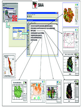
The Agroecological Areas Information System (SIAA) spatially integrates data from the Arc View 3.2 geographic information system (1996), which contains data referring to the agroecological units defined by the National Institute of Agricultural Research (INIA) north of the Orinoco at a scale of 1:250,000.
References
Arnoldus, H., M. J. 1980. An approximation of the the rainfall
factor in the universal soil loss equation. In: De Boodt,
M. and Gabriels, D. (Eds) Assessment of Erosion.
John Wiley and Sons, Chichester, 127-132.
ARC VIEW GIS. 1996. The Geographic Information Sys-
tem for Everyone. Versión 3.2. by ESRI. Product ID:
825921104087.
Cortez, A., M. F. Rodríguez, J. C. Rey, D. Lobo, R. Parra, F.
Ovalles y D. Gabriels 2011. Análisis de la agresividad y
concentración de las precipitaciones en Venezuela.
II. Región Noroccidental. Revista Bioagro, Volumen
23, N°1, 13-18.
Parra, R. y A. Cortez. 2006. Control de calidad de las
series de precipitaciones de las estaciones del INIA-
Venezuela en el periodo 1970-2000. Revista Argen-
tina de Agrometeorología, Volumen 5-6.
Rodríguez, M. F., A. Cortez, M. C. Núñez, F. Ovalles y J.
C. Rey . 2006 Distribución espacial de las redes de
estaciones meteorológicas en Venezuela INIA DI-
VULGA. Vol. 8. Instituto Nacional De Investigaciones
Agrícolas. 7 p
Rodríguez, M. F., A. Cortez y J. C. Rey. 2011. Inorme
nal proyecto Fonacit S1-2002000417. Integración
espacial de los datos agroecológicos del INIA al Norte
del Orinoco de Venezuela. 370 p.
Webster, R. y M. A. Oliver. 1990. Statistical methods in soil
and land resource survey. Oxford University Press.
New York. 307 p.
Published
2011-12-11
How to Cite
Rodríguez, M., Cortez, A., Rey, J., & Parra, R. (2011). Climate Applications in the Information System of Agroecological Areas (SIAA). INIA Divulga, 20(20), 12-15. Retrieved from http://www.publicaciones.inia.gob.ve/index.php/iniadivulga/article/view/984
Section
Artículos